Tuesday, July 21, 2015

Rattlesnake - Mcleod Peak loop

My legs were screaming as I ran the final miles of the Rattlesnake corridor.  A poor recovery from racing, combined with pounding out a half marathon on the flat dirt road had taken its toll, and I still hadn't even caugh a glimpse of the peak.  I briefly considered turning around and just waking out. There was plenty of time as the miles slowly turned over, and I spent time contemplating how much of the wilderness experience is steeped exertion and discomfort. Fortunately, for many, the discomfort magnifies the experience. Wild. Raw. Beautiful. Uncompromising.  All good for the soul, and worth seeking out over and over.  As I passed into the Wilderness, immediately followed by a "Trail not maintained" sign, I couldn't help but smile and continue on.

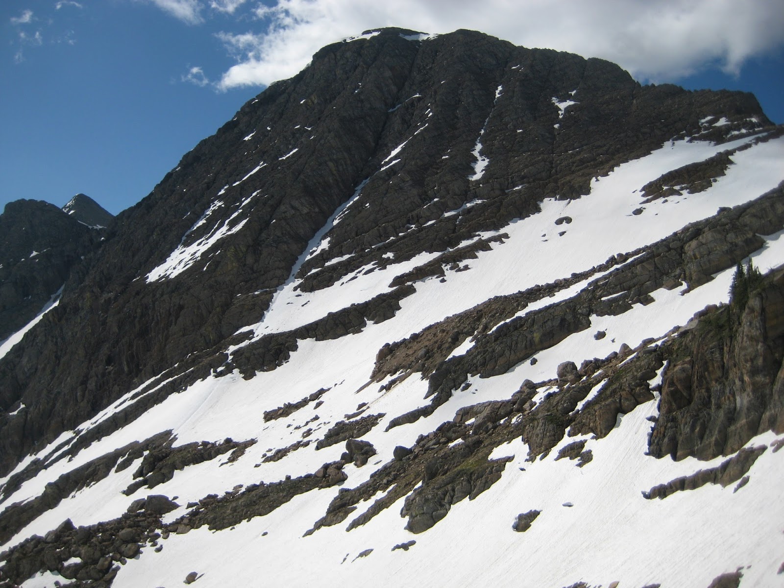
The peaks of the Rattlesnake from Mcleod.  How many can you name?
Mcleod peak is the monarch of the Rattlesnake. It is also tucked way back from civilization, requiring an overnight for most parties.  Having stared at the peak for years, I finally decided to just go big and do the grand tour, running the fifteen miles up the Rattlesnake corridor, climbing the peak, then ridge traversing to the Stuart peak trail, summiting Mosquito and Stuart on the return trip.  In retrospect, this was too much too soon after racing last weekend, but oh well.

The run up the corridor was mind numbing.  Fortunately, the second "half" beyond the Franklin is short, and I hit the trail junction to Mcleod earlier than anticipated.  I followed a surprisingly passable old logging road for almost an hour before striking off to the west on game trails.  It is about two miles off trail to the base of Mcleod, and I simply followed the topography, eventually climbing through a beautiful series of argillite shelves and pocket lakes.  Mcleod was easily climbed on the south face on solid talus.
Typical terrain leading to Mcleod.
Talus on Mcleod.  It was actually quite friendly. 
Bad self portrait on Mcleod, with the Missions in the background.
Mcleod is on the edge of the restricted zone in the Salish Kootenai tribal wilderness, which gives it an appealing forbidden aura. I took a long break on the top to dry my shoes and socks and enjoy the majestic perch. The traverse from Mcleod to the Stuart trail was delightful. Rumors of difficult climbing on the gendarmes at the head of Finley creek were unfounded.  They were slow, but ended up being class 3 fun with some creative ledge scrambling on the east side of the ridge.  It only took two hours to reach the Stuart trail, which I followed for a scant half mile before striking off again for the summit of Mosquito. From Mosquito, I was surprised to make it to Stuart in less than an hour, and took another substantial break on the summit.

Looking back at the gendarmes.
Wildflowers, Glacier Lake, Mosquito peak from the descent off Sanders.
Typical section of the trial from Mosquito to Stuart.

The always rewarding view from Stuart.
The run out was longer than I would have liked.  My right foot hurt like a bugger the whole way, and I tripped on a root and took a spectacular spill.  Fortunately, the trail is perfectly runnable, so I let the legs spin and focused on enjoying the day. Soon enough, I was back in the land of mountain bikers, and a few miles later I was back at the car.
The route and a clear reminder of how awesome it is to have the Rattlesnake in our backyard.
Thoughts
Mcleod is a worthwile outing.  The peak is probably most easily climbed by biking up the corridor, then climbing from the Wilderness boundary on foot.  Done in this manner, it could be completed by a competent hiking party in a long day. The peak could also be climbed from Snowbowl and Murphy peak as a high quality out and back ridge scramble. Even though it is longer, my loop was was definitive and highly recommended.  Just be sure you have the running legs to comfortably stack a day of peak scrambling on top of 25 miles of trial running. I didn't on Saturday, and paid the price a little on the egress.  Less then 7,000 vertical feet but well over 35 miles and done in 10 hours, 5 minutes car to car at a moderately bright pace.

Sunday, June 28, 2015

Missions - McDonald, Panoramic, St. Charles link up

Leah nearing Point St. Charles.

Record temperatures were not enough to keep Leah and me from putting in another great day in the Missions. We drove out to the Glacier lake trailhead the previous night, which helped take the sting out of the 5 am start. We hit the trail at first light and made quick work to Heart lake. We endured "pretty bad" bushwacking and hordes of mosquitos on the hike up to Island lake, but fortunately we were though before it got too hot. It was nice to top out on the divide by mid morning, and we were soon well on our way up McDonald peak. The climb up McDonald was just one long, hot, snow slog, but we made good time. On the summit, we were surprised to see no less than three parties, 17 people, and at least two dogs climbing the peak from all directions. Popular place, I guess.
Early morning light at Heart lake.
Bushwacking. It was worse than it looks in the picture.
Nearing the crest of the range on the way out to McDonald.
Leah fording Post Creek. Game face.
Climbing the East face of McDonald.
We were able to easily glissade the East face without an axe or crampons, and took a short break to cool off at Icefloe lake. A good hard push put us at Lake of the Couds, and another push put us on Panoramic peak. We had a nice long shoes-off-to-dry break on the summit.  The ridge to Point St. Charles ended up being too exposed, so we bypassed it on the north, and were treated to some terrible scree, steep snow, and fun but slow 4th class rock on the way to St. Charles. The egress to the car was nice and slow and relaxed. We were hot and tired, but the bushwacking was minimal, and the trail back was smooth and easy. A rejuvenating swim near Turquoise lake also helped. Even with the easy egress, we were both ready to get out, switch to flip flops, and drink a beer at the end of a day well spent.
Glissading near the bottom of McDonald peak.
Lake of the Clouds on the way to Panoramic point.
Leah on the traverse from Panoramic point to St. Charles.
Working the steep final pitches to Point St. Charles.
Thoughts
This is a pretty good traverse, but the drive is long enough, and there is enough adversity (mainly bushwacking) to keep it out of the "must repeat as often as possible" category.  I hadn't been on the east side trails in several years, and aside from some painfully flat switchbacks, they are well maintained and generally fabulous. It was surprising to see so many people on the mountain, especially since McDonald is so much easier to access with skis in the spring, but it is always good to see people getting after it. As a note of warning, mosquitos are out so don't be surprised.  Somewhere north of 8,000 vert done in a little over 15 hours car to car. Also, there must be a better way to get from Heart to Island lake. It would make the day a lot smoother. We took the shortest route between the lakes, but I wonder if it would be better to do a high traverse to the Island/Cliff pass from the north.

Thursday, June 18, 2015

Mission Traverse V.5

Nearing the halfway point of the traverse below the South face of McDonald peak.
I was fortunate to find time and energy between races for a long day in the mountains, and the Mission traverse was an easy choice. I still contend the Mission traverse is the finest long outing near Missoula.  I followed my previous route with only a few modifications, and it was delightful to spend a long day in familiar terrain, simply moving and enjoying the experience.

I ran the bike shuttle the previous evening, and was jogging from the canal at the bottom of the Ashley lake road at dawn.  The bushwack to Sheepshead was as slow, but I was mentally prepared. It isn't really that bad, just slow and long. Soon enough, I was on the enjoyable Southwest ridge of Sheepshead, which I followed easily to the summit. Something in my digestive system was a little off, but otherwise I arrived on the summit right on schedule, and in good spirits. The traverse to McDonald was quick and easy.  A brisk wind discouraged me from stopping on the summit, so I immediately started glissading the South face.  Aside from a few sections of steeper snow, I was able to carefully glissade or butt slide the entire way, descending 2,000 vertical feet in less than 10 minutes. I found a good water refill spot near the Ashley/Post divide and took a short break.  

Lots of downfall on the historic trail to Sheepshead.
In high spirits on McDonald.  Looking to Flattop and Kakashke.
Glissading on the South face of McDonald.
Instead of descending to Icefloe lake, I stayed high and climbed North Glacier peak via the North face and West ridge. This was my first time on the ridge, and I was pleased to find enjoyable 4th class climbing all the way to the summit. My stomach hit a low point on the traverse to the South summit, but a few cookies and a shot of gel were all it took to turn things around, and I ended up feeling great for the rest of the day.  I hit South Glacier several hours ahead of schedule and kept pushing to the Garden Wall. I took a full break, drying my shoes and socks and dining on grapefruit and jerkey. The climb to Mountaineer was quick using the west ledge bypass, as was the convoluted route to the Fissure glacier. I had plenty of time to hit Lowary, so I climbed it via the easy Southeast ridge, and made the quick jaunt out to East Saint Mary's. I was pleasantly fatigued by this point, but there was still enough pep in the legs to enjoy the long, steep trail run back down to the reservoir and car.  For stats, somewhere north of 11,000 vertical feet with difficulties to 4th class and bushwacking which never exceeds "Not too bad," done in 12 hours 1 minute.  Such a good outing.

The North face and West ridge of North Glacier peak. From the Ashley/Post creek divide,
I ascended the big snow ramp to near its terminus before scrambling 4th class rock to the visible West ridge.
Starting up the West ridge of North Glacier peak.  Fun exposed 4th class scrambling.

Lunch break on the Garden Wall.

Descending to the Fissure glacier, briefly wishing I had skis.

Classic Garden Wall view from South Glacier peak.

Sunday, May 31, 2015

Holland Peak, Northeast Face

I took advantage of the end of an extended period of exceptional ski conditions to ski the Northeast face of Holland peak.  The face is comprised of a complicated series of limestone ledges, and my chosen route pieces them together in the most logical way possible.
At the end of the difficulties, looking back up at the ski run.
I had a great nigh of sleep at the trailhead, recovering as much as possible from a long ski adventure the previous day. I awoke refreshed and was soon on the trail, hiking at a nice steady pace. Snowline is high, and I walked almost to the lower lake before putting ski boots on.  Snow conditions were firm, so I put crampons and punched it all the way to the crest of the range. It was a cold, clear, beautiful spring day in the mountains.  I skied a short run to the east, avoiding slabs and nasty glide cracks on the normal summer route to Holland. I got my first look at the face after skinning up to the east ridge.  The lower portion of the face had avalanched down to rock slabs in the past few weeks, and from my vantage point, it was unclear if it would be in skiable condition. Fortunately, I had a better view from the summit. It appeared that the line line was intact.  The timing was right on, so I decided to at least have a look. I did my slow pre-run ritual, throwing down some extra calories, meticulously clicking into my skis and checking my gear, stretching, relaxing,  and mentally preparing.

Looking down the Northeast face from the summit ridge, wondering if it will go.
The upper face was in fine condition, with a few inches of consolidated graupel overlying a firm base.  I navigated the first shelf without incedent, then traversed slowly to the second band. After a few turns, I found a way through the second band and started sideslipping. The snow was icy and very steep as I worked through the second band, but I just kept moving slowly, and the way opened up.  I lost my nerve a little through this section.  To my surprise, the ice had softened slightly on the traverse across runnels to the exit choke, and I was able to slowly work my way off the face without having to negotiate anything too scary.  Below the exit choke, I relaxed and skied along the edge of the debris all the way down to the end of the snow nearly 3,000 vertical feet below the summit.
In the thick of it.
The climb out from the east side of Holland is exposed to avalanches, so I only stopped briefly at the bottom. The climb required walking through endless and massive avalanche debris and some steep skinning and booting, but I arrived at the exit notch on the north ridge without incident.  Finally, I was able to relax and plot out the rest of the day.  I had two great runs on the way out, one down to upper Rumble lake, then one from just a few feet below the crest of the range down through the excellent couloir above lower Rumble lake (this run is a worthy stand alone ski objective).  The jog out was pleasant.
Relieved to be at the exit notch.
Exit couloir.
Thoughts:
The Northeast face of Holland Peak is a great challenge for those seeking difficult descents. It is prominent, steep, complex, long, and committing, and hard to catch in condition.  The skiing is good.  I am guessing this is a first decent. Anyone know otherwise? I don't really play the steep skiing game much anymore, but it is engaging to throw my hat into the game once in a while. Somewhere around 10,000 vertical feet done in around 10 hours.

Steep skiing food for thought
Skiing true no-fall terrain is dangerous. These words from the sage Lou Dawson struck a chord with me as I find myself slowly and happily transitioning out of the steep skiing game.

A few things have helped me cope over the years with motivation and goals. One of the biggest was realizing that life as an alpinist is a series of phases, and even at the most aggressive phase each participant has their personal goals and motivations, most importantly that some may choose a career of extreme skiing as a mission of passion and perhaps way of making a living, but it’s not for everyone and it’s also fairly risky.

I truly believe the... media is doing a disservice to our population as a whole by the constant barrage of content that makes it appear that to have fun or value from skiing it has to be done on steep terrain and even with a level of violence (tomahawking, failed “sluff management,” broken necks and on and on.). 

Such is not the case in real life. Traveling in ski touring oriented countries such as Austria and Norway has really helped me see this, but it’s a style and lesson one can glean in North America as well just by paying attention to what really makes you happy in the mountains, as well as what gets the smiles from your friends, loved ones, and people you meet along the way.

If your calling is the steeps and hardcore alpinism, then it is, but it’s a great big world with lots of options.  Lou Dawson, 2015

Tuesday, May 19, 2015

Lolo Peak Ski for time

Skiing off the summit.
With snowline marching rapidly up the hillsides, I dragged myself out of bed in the dark and made a speed run on Lolo Peak.  I gave it a full effort. No activity the day before, coffee to suppress the early morning sleepies, race skis, dialed route, etc.

The circuit went about as smoothly as could be expected. I went out at a hard sub-threshold pace, which felt like full effort at 6 am. I made one quick skis on transition at snowline, then a long transition on top of Carlton ridge, well ahead of my previous best time. The snow was consolidated and fast, which allowed me to skate around the lake.  I slapped skins on, sucked down some calories, and pinned it up into the fog. The snow on Lolo peak was grippy, skiinable ice, and I was able to top out well ahead of my previous best time at a hard but sustainable pace. 

To my delight, the summit was just above the clouds, and it was pretty cool to look and only see the tippy tops of the Bitterroot summits poking above the clouds.  I skied slowly back down to Carlton lake, taking time to manage the ice. Also, I couldn't see anything with the fog, so I blindly followed ski tracks.  Another long skate around the lake and a quick hard skin back to Carlton had me transitioning about 20 minutes ahead of my previous pace.  It is almost impossible to not get a little turned around on the ski back down from Carlton, and this time was no different.  I detoured off to the left, but a long summer trail switchback put me back on the main skin track.  I skipped a few patches of snow before throwing the skis on the back, stripping to a t-shirt, and clunking down the last two miles to the trailhead at a respectable running pace in ski boots.  2 hrs, 15 mins, 20 seconds.

Excited to have shaved a half hour off my previous time.
Splits for future reference: Mill creek junction 0.12; Carlton outbound 0.54; Starting up Lolo 1.02; Leaving summit 1.29; Carlton inbound 1.52; trailhead 2.15.20

This is a solid time for me. The day went off without a hitch and conditions were fast. The only way to go significantly faster would be to push at  full race pace or show up with better fitness. Running in ski boots kind of sucks, but doing it all in ski boots is critical for a solid time. For general information, skiiable snow is about half way up. Overall coverage is still good, and it should be that way for another week at least. Also, MTB Missoula in collaboration with the Forest Service has cleared the Lolo and Mill creek trails.  Thanks guys.