Friday, April 27, 2018

South Swan traverse, Crescent to Divine

I have been chomping at the bit for spring skiing.  With with winter sticking around for a few more days, we headed out on a tour that I have wanted to to for several years, but also one with sneaks to avoid wind loaded starting zones and feasible bail options. More of an assertive bite than a chomp, but one that worked out well.
Mist skiers on West Marshall.
Leaving town at 5 am in a driving rain would have been demoralizing if not for Jeffrey and Conor's motivation.  In an unusual turn of good luck, the precipitation abated as we headed to Seeley, and it was dry by the time we were skiing.  The six mile flat road skin went by in a monotonous but quick two hours, and we were soon navigating up the Southwest ridge of Crescent.  Snow from the past few days made trailbreaking arduous, and I almost lost a skin (thanks Jeffrey for the day-saving ski strap). We still summited in good time.
Jeffrey approaching in the Rice Ridge fire area. Photo: Conor Phelan
High on Crescent. Photo: Conor Phelan
Starting down Crescent. "I think it goes" Photo: Conor Phelan
We skied off the summit of Crescent in a whiteout but somehow nailed the Southwest gully line, navigating by braille.  It was terribly ironic to not be able to see a thing while skiing a beautiful line on a visually stunning peak, but such is life at times.  Conor crushed the trailbreaking to West Marshall, and we just tried to keep up.  We topped out once again in a whiteout, but had more ease finding the gully, and also skied much better snow.  Avalanche danger was above low, and throughout the tour, we would ski a hundred feet of relatively wind scoured west aspects to bypass the starting zones before skiing the majority of the gullies with confidence. Once again, Conor crushed the first half of the climb up Pyramid, and I was able to take it to the summit.  To our surprise, we saw Dave and his friend Kurt descending as we climbed.  I used Dave's blog post extensively for trip planning, but in characteristic shyness did not thank him for the beta.  My bad, thanks Dave!  The clouds finally broke as we summited Pyramid.
Jeffrey near the bottom of the West Marshall run.
Conor on the last few steps to Pyramid.
Jeffrey enjoying the Pyramid run.
We were all tired, but there was sufficient time in the day to extend the tour and visibility was finally reasonable, so we took a truncated run of the South side of Pyramid, then made a short climb to an unnamed sub peak, which allowed us to ski a fun gully to the summer Pyramid Pass trail.  I was knackered from tough trailbreaking at a bright pace, and the last climb to Divine was a grind.  But we made it.  Most of the South gully was great fun, and with careful ski cutting and good communication, everything was manageable enough to be safe below saturated mush line.  It is a haul to get out, but the sun was out and everyone held it together.  
Onward to Divine, the white peak in the background! Photo: Conor Phelan
Conor leading us to Divine.
Skiing on fried legs midway down the Divine run.
Exit.  Seven miles. Flat roads. Two hours.  Photo: Conor Phelan
Thoughts
Thanks to Conor and Jeffrey for the great tour.  For stats, 10,700 vertical feet, done in about 12 hours car to car.  Conor's watch read 26.1 miles, but our feet were so sad by the end of the day, that we had no motivation to tack on the five hundred feet to make it a proper mountain marathon.  

I think that a simplified Crescent/West Marshall/Pyramid traverse would be a Missoula area classic if there were more backcountry skiers, and one that can be done mid-winter with reasonable avalanche conditions.  By skiing the unnamed West Marshall, the whole day can flow in a tight, logical sequence. The ski runs are all fabulous, the peaks are striking, the lines links up elegantly, and the length is a manageable 8,000 vertical feet. The only real detractors are that the ingress and egress are long, ski quality is fickle with all the runs on solar aspects, and the low elevation climb up Crescent might be trying with a thin snowpack. This is one area where a snowmobile would safe considerable time and energy. 

Sunday, April 22, 2018

Gash to Sweathouse, the Sweaty Gashes

With larger objectives still on the shelf until the firehose of precipitation abates, I spent two long half days exploring safer low elevation terrain at Gash.
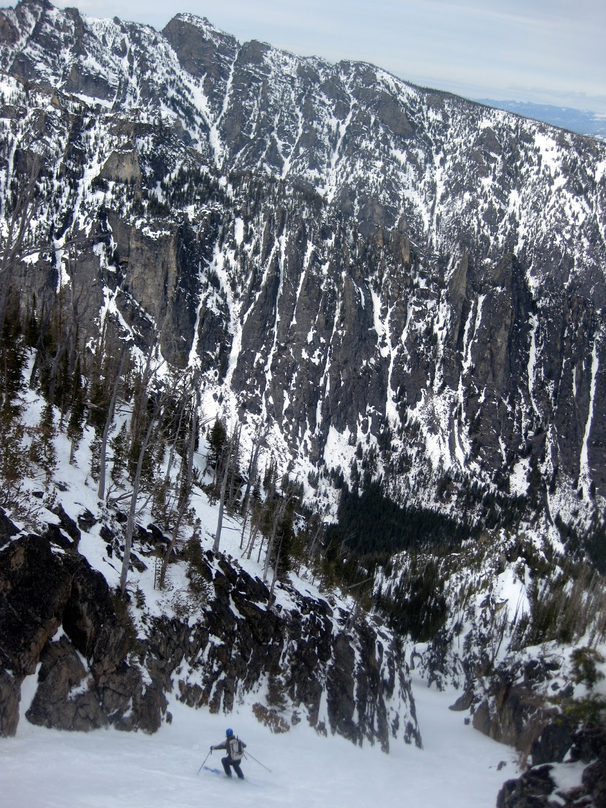
The Sweaty Gashes.  The obvious avalanche path is below Gash proper. 
The upper bowl and shoulder run are in the center of the photo.
The lower chutes still need to be skied.
Day 1  I left work at noon on Friday and headed straight for Gash, parking at the end of the plowing. I approached the upper Sweaty Gash bowl in a pervasive mist.  It blew out by the time I was nearing the drop in point, which helped mightily in deciphering the terrain.  I was relieved to see the heavy new snow from the week sufficiently consolidated to keep avalanche conditions reasonable.  I got things rolling by skiing a short chute into the main upper bowl, then took it all the way to the creek.  The underlying snowpack was terribly rain saturated, but somehow it skied OK top to bottom.  During the long climb back to the Gash ridge, I spotted a West facing tree lined gully and decided to ski it. The run ended up being more scrappy than desired, oh well.  I stopped about 600 feet above the creek in order to save time for a third run.  After climbing back out, I skied another good couloir into the same bowl just east of my first run.  At this point it was 7 pm and time to head home.  I fueled up, punched up my track for the last time, and rallied out to the car by dark.  I had so much fun exploring that the drive home was spent scheming a return trip.  About 7,600 vertical feet done in 7.5 hours.
Looking down the first run.
Second scrappy run.
Looking down the third run.
Nice moderate terrain in the lower bowl.
Day 2  With Leah out of town, I took a Wednesday off from work but only had ten hours between daycare drop off and pick up to work with.  I returned to Gash, this time driving to the last big dry turnaround about a mile from the trailhead.  I must have misread the forecast, because it had rained overnight instead of snowing, but I headed out into the mist anyway.  I had planned on skiing the lowest North chute off Gash, but blew right by it in the mist.  By the time I realized my error, I was already at the upper Sweaty Gash bowl.  So, I skied a great run down the West shoulder which eventually dumps into the main bowl.  I think this shoulder run is the best line in the cirque.  I made a quick transition at Sweathouse creek, and started up a 2,000 foot couloir directly across the drainage.  The climbing was quick with only one short section of booting, which allowed me to bang out the ascent in an hour.  The couloir was a stunner.  The upper half is a remarkably clean, and the bottom half skied well.  Motivated, I made a quick transition and traversed up canyon to a less aesthetic but still fun looking 2,400 foot couloir.  I was able to skin the whole thing, and topped out in good time.  The day had warmed up enough that snow quality was poor, especially below rain line, but it was a great run.  At this point in the day I had only three hours to be back in town for daycare pickup, so I downed some calories and started up my skin track from last Friday.  The calories were enough to sustain a 50kish pace, and I topped out tired but with time to spare.  The schuss out to the car was uneventful.  9,600 vertical feet, done in 6 hours, 40 minutes at a bright pace.
Starting down the first run.  My third run was in the curving gully with the
open V-shaped snowfield in the center of the photo.
Looking across at the clean second run couloir.
Looking down the clean second run couloir.
Mid way up the third run with a very well filled in Gash proper in the background.
the upper section of the third run.  Better than it looks.
Photo was taken in flip flops.  Ski to car!
Thoughts
This is a great zone, and I would love to know if any of the runs or name have been named. It is unusual to have enough snow to ski some of these lines, but when in condition, they are worth it.  I think the shoulder run into the upper Sweaty Gash bowl is good and safe enough to mix into the normal Gash rotation.  

On a health note, still coming back from the long pneumonia, but I am finally getting my mojo back.

At a minimum, I need to go back and ski two more of the North couloirs from Gash. 

Monday, April 2, 2018

North Trapper new routes


Ned skiing Hidden couloir.
Ned was kind enough to join for an exploratory mission to the Trapper group.  It was potentially unwise to roll the dice on something new when good conditions in the Bitterroot will only last another few weeks, but fortunately we got lucky.

The approach up Trapper creek was worse than I remembered.  The trail is choked with downfall, and we completely lost it after the creek crossing.  The climb into the cirque is steep and complex, but we were able to nose (and routefind by map) our way remarkably easily.  To my dismay, freezing level was way up at 7,000 feet, but conditions were good and stable above there.

The stream crossing was just one of the many delights on the approach.
Our first line was the Northeast ramps off the Northeast shoulder of North Trapper.  This gully and face always looked too broken and complex to pique my interest, but it was great fun as a mountaineering objective.  After booting the 1,000' clean opening couloir to a showstopper ice bulge, we traversed west onto a hanging ramp system.  From there, it was a long wallow to the top.  We were stymied 20 vertical feet from the ridge top by nipple deep sugar and my lack of climbing head.  The skiing was great. A short 55 degree headwall got us down to the ramps, which were exposed but moderate, and the couloir was great fun, with good chalky snow.  Thanks to Ned for his competence in getting this line done safely.  At the bottom of the run, we stopped for lunch and made a plan for the remaining two hours.
The Northeast ramp line is in the sun/shade gully. Hidden couloir is in the,
you guessed it, hidden gully just right of the most prominent rock ridge.
Approaching the Northeast ramps.  Photo: Ned Gall
Ned climbing the ramps.
It's not all glamor. Ned slightly defeated in his wallow hole, putting skis on.
First steep turns above the moat at the top
of the Northeast ramps. Photo: Ned Gall
Turning the corner into the couloir.
Ned ripping the better and longer than it looks couloir.
Just coming off a terrible four weeks of pneumonia, I had made it clear that I would keep it mellow and head out after one run if necessary.  Fortunately I felt good enough to do another run, so we traversed to the next cirque west to "have a look". The traverse was interesting, but we eventually made it.  To my absolute delight, the cirque headwall was split by a clean 1,200 foot couloir.  Up we went.  The couloir was moderate enough that we were able to skin about half of it, and the booting was easy enough.  From the point of highest skiable snow, we walked up to the crest and were treated to a jaw dropping view of the Antonilli ridge on North Trapper and the Cave lake cirque.  Skiing Hidden couloir was a treat. So much fun.  The ski down below freezing line was OK, and the exit was slow and schwackey, but we made it.  About 7,000 vertical feet, done in ten hours car to car.
Ned climbs and marvels at beautiful granite walls.

Majestic North Trapper view.
Skiing Hidden couloir.
Thoughts
These are great lines.  Hidden in particular is one of the longer rock lined couloirs I can think of in the range. It is also moderate and objectively fairly safe.  I would probably ski the area classics like Sugarloaf, the Tin Cup Chutes, Trapper North Gully, North Trapper Southeast face, and the Goddess first, but after that, these lines are highly recommended when there is enough snow to get in and out.  It was delightful to get out skiing again.  Fingers crossed on a few more Bitterroot adventures before the low elevation snow melts.

Sunday, April 1, 2018

Castle shoulder tour

I teamed up with a large group of Missoula's finest to shake out the daylight saving cobwebs and do more exploring in the Bitterroot.  We took advantage of having two vehicles to do a short shuttle from Fred Burr to Sheafman.  In retrospect, one could just do the tour from Fred Burr, but it was fun to go point to point.  The snow was heavy and somewhat forgettable, but both ski runs were good, and it was fun to tuck ourselves under the commanding rock face at the base of Castle crag. I was sick, so tanks to everyone for all the trailbreaking and putting up with all my coughing and wheezing.
Sunrise! (All photos: Conor Phelan)
Stable enough pit above Knack lake.
Climbing to Castle crag.  Spectacular spot.
At the bottom of the Castle crag run.
Nearing the top of the second climb. I had wanted to sketch up the ramp on looker's right,
but time and conditions did not allow.  Maybe next time.
Starting our second run.  John exhibiting magnificent euro flare. 
The classic Fred Bur reservoir view while exiting.
The tour. Up Sheafman to base of Castle Crag NE ridge, down NE shoulder into Fred Burr.  Up to ridge on Northeast flank of Castle crag, down North to the creek. Out Fred Burr.