Monday, July 31, 2017

Lucifer Loop in the Missions

" I can't help but dream about a traverse around the rim of Mission creek, from the Sonielem ridge to Kakashe. Maybe someone fast can go do it and let me know how it goes..."   
My brain, three years ago, after doing the Sonielem ridge traverse.

Bad bushwacking, pretty flowers.
No complaints on the climb to Kakashe.
I have not become any faster, but with a full day to burn, I decided to give it a go. With good familiarity with most of the route, I did a some meager Google Earth research on the approach to Kakashe, quickly packed a running pack on Friday night, and rolled out of bed at 3:30 am the next morning.  The early morning drive and trail approach to Mission falls went smoothly.  I had anticipated leaving the trail where it opens up above Mission falls, but the brush looked awful, so I decided to take the trail toward Lucifer, hoping for a cleaner approach gully.  I ended up leaving the trail in the primary avalanche path just before the lake, climbing for about 800 vertical feet, then making a long traverse back west to the base of Kakashe.  In retrospect, I think there is probably a faster approach from the valley, possibly on the historic Kakashe trail, but my route worked, and the bushwacking was Not too Bad.  Which passes for success in the Missions.  
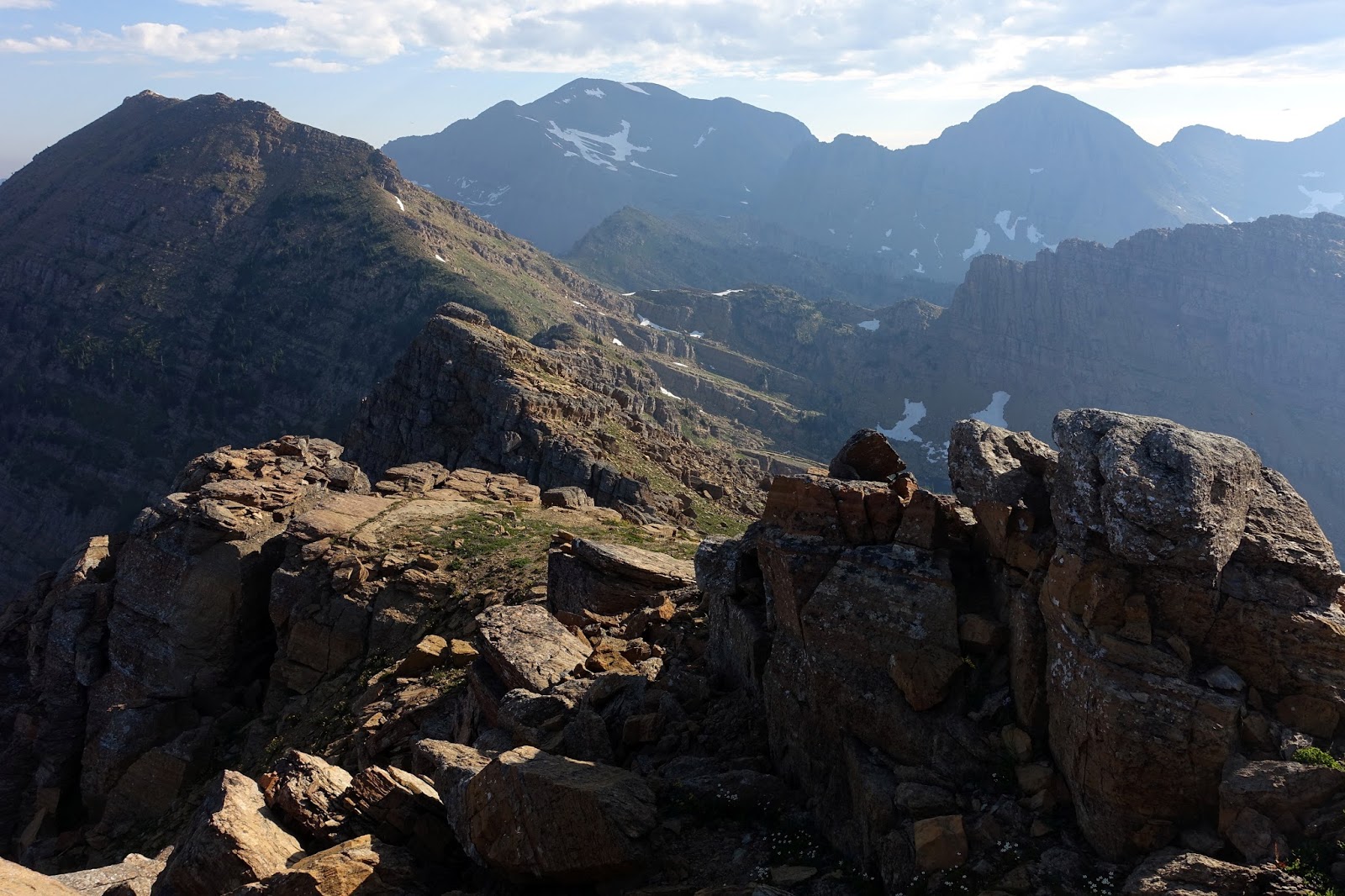
Delicious distractions along the way.

Kakashe, finally in sight.
Chipper and psyched on the first summit.
Fun-enough terrain between Kakashe and Flattop.
From the summit of Kakashe (3.5 hours), I easily made my way to Flattop.  It was great to finally summit these two prominent Mission mountains.  The traverse from Flattop to the base of Icefloe peak was a little longer than anticipated, but it was easy.  I was mildly concerned that the west face of Icefloe would be too difficult, but the gully system ended up being reasonable, and it merged seamlessly with the enjoyable 4th class northwest ridge of Icefloe.  Having kept up on food and water, I walked over the summit of Icefloe and continued on familiar terrain to Glacier peak (7 hours).  From there, I made another delightful jaunt across the Garden Wall and climbed Mountaineer.  
Looking up the West face of Icefloe.
I took the gully system just looker's right of center.
Good times on the Garden Wall.
Beta photo:  This is the point to leave the north ridge of Mountaineer for the ledge traverse.
Note the yellow rock on the ridge.
I have made the traverse from Mountaineer to Lowary at least six times now.  It is not my favorite section.  So I just got it done.  It may sound odd, but the highlight was the psychological challenge of pushing through fatigue to summit Lowary with many hours to go in the day.  To save time, I climbed Lowary directly via the northeast face instead of my usual route from Vacation pass (10 hours).  The Sonielem ridge traverse was a lot of fun.  I ended up bypassed all of the tricky rock steps on the west, and was reminded how wild, aesthetic, and generally enjoyable this section is.  Getting off the Sonielem ridge took a long time, but was not as bad as I had feared.  There are a lot of cliffs to negotiate, but my seat-of-the-pants, intuition based routefinding worked.  The bushwack to the lake was a very solid Pretty Bad on the bushwacking scale.  I had to get a little creative, downclimbing mossy chimneys through cliff bands and swimming through brush, but I made it.  The run out on the trail was fun.  I took it easy and made it out just over an hour from leaving the lake.

Steep loose scree, no summits in the near future.
 In the less fun bits between Mountaineer and Lowary.
Looking out along the Soneilm ridge.
Tired and psyched on the last summit.
Looking down the steep exit off the Sonielem ridge.
Committed. Time for some serious routefinding by intuition.
Thoughts  
I have been dealing with an ongoing low level left knee injury for several months, and the day was very hard on it.  After a string of flawless running outings, it started hurting early in the day, and it slowed my progress down significantly on flat and downhill terrain.  And, after two days, it has still not fully recovered.  In any case, the route itself was great.  There is quite a bit of blue collar bushwacking, but that should be expected in the Missions, and the trade-off in pure wild terrain is debatably worth it.  The alpine line itself is not the cleanest, but it is still a logical and challenging route.  It is outside the Grizzly closure,  bailing throughout the entire route is at least possible, and the simple logistics of the loop are appealing.  I would rather do the Mission traverse, given the choice, but the Lucifer loop is still a good one.
Rough sketch of the route, not including the trail.
Statistics
Route: Up Mission Falls trail to within 1/4 mile of lake.  Up to Kakashe.  Along ridgeline over Flattop, Icefloe, Glacier, Garden Wall, Mountaineer, North Lowary and across the Sonielem ridge.  Down the NE end of the Sonielem ridge to Lucifer lake. Out on the Mission Falls trail.
Approximate total elevation gain:  10,900 vertical feet
Length: ? miles done in 14 hours, 15 minutes
Accomplices: No
Put in:  Mission Falls trailhead
Take out: Same
Fuel: Peanuts, bars, gel, lots of snowmelt water. Averaged about 150 cal/hr.
Equipment:   Not much. Bear spray just in case.  A good map.
Tricks of the day: Knowing most of the route well ahead of time.
Stoke factor (1-10): 8
Fatigue factor (1-10): 7
Memories to suppress:  Knee pain.

Wednesday, July 19, 2017

Norris traverse + Logan and Jackson

On the Logan extension to the Norris traverse.
The Norris traverse has been on my dream list for more than a decade.

Needless to say, I jumped when weather, conditions, and time aligned to make it happen.  After a week of resting, dreaming and scheming, Jeffrey and I left work a few hours early on Friday afternoon and set up the car shuttle.  Sleep came easily, but we were both excited enough to easily hop out of sleeping bags at 2:30 am.

The trail up to Triple Divide pass went quickly by headlamp.  We spooked a large animal of some kind, but otherwise it was just walking and easy running, waiting for first light.  From the pass, there was just enough light to scout a route on the steep east face of Triple Divide peak.  We had to do a bit of routefinding on the face, but the climb went quickly, with just a few 4th class steps, and we were on the summit at sunrise.  The traverse to Norris mountain was quick, and we easily climbed classic stout 3rd class GNP terrain to the summit.

Already in interesting terrain at first light.
One of many.
Jeffrey a few steps below the summit of Norris mountain.
After a bit of loose down climbing on the West side, we were off an running on the fast and enjoyable ridgeline terrain that would take us to Red Eagle pass.  The traverse to the pass took three hours, and it was quite enjoyable.  We roughly followed the guidebook directions, bypassing the ridge high points on goat trails. We did a bit of bushwacking across the basin, bit it was not too bad, and we arrived at the far side in good spirits.  A long break ensued, which involved food, a full water refill, a map check, and route discussion.  Since we were right on schedule, we abandoned the traditional route and instead climbed loose 4th class chimneys to the flat saddle between Clyde and Logan (described as the Scenic Death March in the guidebook).  The rock was poor, but we made it.  The climb to Logan was great.  Ledgey, loose but not too bad, and long - classic Glacier.
Looking ahead along the traverse from Norris Mountain.

Off route on the descent to Red Eagle pass.
Looking back to Clyde peak and the early portion of the traverse from Logan.
Looking out to Blackfoot and Jackson from Logan.
From the summit, we dropped on to the Blackfoot glacier and traversed to the base of Logan along the ridge line with occasional dips into the snow to avoid cliffy terrain on the crest.  Steep snow slowed us a bit, but ice axes kept it manageable as we pushed up Blackfoot.  We arrived on the summit in good spirits, but a little overwhelmed by fatigue.  This combined with thunderclouds on the horizon and being about an hour behind schedule made it an easy decision to start heading home.  Getting across the bergschrund of the standard route on Blackfoot was horrendous.  We ended up having to do an altogether too risky belly flop over thinly bridged snow, and I did not like it at all.  In the future, I would get off the glacier by weaving through crevasses about a quarter mile farther south.
On Blackfoot.
Careful traversing above the bergschrund on the Blackfoot glacier.
We were now well above the standard Norris traverse, and I did not have any prior information on how to get off the glacier, so we spend about half an hour dinking around before we found a loose but suitable exit down the west lateral moraine of the glacier.  It was a little slow, but the setting was absolutely spectacular, and we weren't in a hurry.  Jeffrey and I had a difference of opinion on how to cross the main stream channel below the glacier.  We ended up taking my route, but I waded back into the stream to give a hand in getting across the swift thigh deep stream.  We also wandered a bit trying to locate the Jackson glacier trail, but eventually found it and were on our way out.  The run out is about seven miles, with a mile of uphill at the end.  Amazingly, the day was not to hot, and our legs were not too hammered, so we were able to get it done in about ninety minutes. The car was a welcome sight.  Very roughly 30 miles and 8,000 vertical feet, done in around 14 hours, 30 minutes car to car.
Wild scenery below the Blackfoot glacier.
Back on the trail and cruising.
Thoughts
This was a great outing, and the first big day I have had in almost a year.  The length and technical difficulties of the classic Norris traverse are quite reasonable.  At the risk of sandbagging, I believe this outing is in reach for strong hiking parties and normal running parties with excellent routefinding skills, and would encourage people to do it in a day, as opposed to the traditional three days.  The classic Norris would also be easier in the normal Gunsight to Cutbank direction.

Our extension was a lot of fun, and I would recommend it.  However, I would not recommend the standard bergschrund descent off Blackfoot mountain, as it was dangerous. In fact, it would have probably been more logical to simply add Logan and not Blackfoot.  Adding Jackson would be pretty amazing.  It looked reasonably doable, at least as long as one detoured out to the standard Northeast ridge route.  The south ridge would provide a steep and spectacular end to the outing, but I was worried about it being too ledgey and technical.  Would love to hear from anyone with more knowledge of the route.

Monday, July 10, 2017

Redstone traverse in the Scapegoat

I have been excited to explore more in the Scapegoat and Bob Marshall wilderness complexes, so when a rare mid-week day opened up, I drove out to Copper creek with plans for a nice long traverse over Red Mountain, the highest point in the Scapegoat. 
Red mountain in sight from about halfway along the ridge.
I rolled out of my sleeping bag in the back of the truck at first light, and was running from the Indian Meadows trailhead at 5:45 am.  The two miles of dirt road went quickly, and I was soon running up the Snowbank trail to Stonewall mountain.  I had feared the trail would be faint and clogged with fire blowdown, but it ended up being runnable with only a dozen down trees.  I eventually topped out on the more heavily used Stonewall ATV trail, and ran up to the lookout.  The pace was probably a little bright.  I arrived at the lookout 2.5 hours into the day.
Snowbank trail at sunrise. 
Rolling up to Stonewall.
From Stonewall, I began working along the seven mile ridgeline to Red Mountain.  In this direction, the character of the ridge becomes more appealing for the duration of the traverse.  The first hour plus was below treeline, and I walked a lot through beargrass, punchy snow, and downfall from recent fires.  But it was never even quite bad enough to count as bushwacking, and I was soon on cleaner and faster terrain.  I worked through countless short ups and downs for the next few hours, taking advantage of late season snow in many places to bypass slower rugged terrain on the ridge crest.  Soon enough, I was at the saddle where the historic mining road intersects the divide.  My stomach was a touch off, so I took a few minutes to eat some real food and regroup.
More fun terrain along the traverse.
Snow made or quick travel.
The section from the saddle over Blonde mountain to Red was sublime and altogether too short.  I did see a grizzly bear, but it ran off when I yelled, and I had bear spray, so the encounter was not scary.
Hey Bear.
Looking back from Red mountain.
Heading home.
As has been the case with slightly lower fitness, I hit the final summit with heavy legs, not sure how the eleven mile run out was going to go.  Fortunately, the legs came around, and I spent a delightful two hours running through well maintained trails, stopping regularly to soak my shirt and generally wage war on the heat.  And soon I was back at the car, happy, tired, and almost two hours ahead of schedule.  26 miles and about 6,000 vertical feet done in 8.45 at a bright pace given the duration of the outing.  2.5 hours to Stonewall, 4.5 hours on the ridge, just under 2 hours on the trail exit.

Thoughts:  Great traverse.  It was fun to do a completely non-technical outing and move fast(ish) all day.  I would go back and do it again for sure.  There are two shorter outings that would perhaps be even higher quality:

1) Park at the Copper creek gate, bike downhill about 7 miles to the Indian Meadows trailhead, run trails to the summit of Red, and returning to the car via the ~2-mile ridge traverse south and mining road extension of the main Copper creek road.  This would be a more condensed and high quality loop.

2) A simple out and back ascent of Red mountain from the Copper creek gate via the main road and long south ridge would be an excellent moderate day hike.