Friday, May 31, 2013

Northern Tobacco Root Memorial day skiing

Steep skinning in the Brannan lake cirque.
Leah and I spent an extended Memorial day skiing above Sailor lake in the Northern Tobacco Roots.  The weather was a little worse than forecast, and the trip included plentiful reading time, hours of listening to rain and sleet pitter pattering away on the tent, and a few dramatic claps of lightening.  The skiing was fantastic, however, and we were treated to an oversized helping of moderate couloirs in a new (for us) and relatively unexplored corner of the range.  I have been planning this trip for nine years, so it was good to finally see the terrain instead of endlessly drooling over maps.

With a casual start from Missoula, we spent the first day approaching Sailor lake with heavy packs and establishing a fantastic camp just below the lake.  We had time to make an evening ski of the south twin couloir in the central cirque and get a general look at the available terrain.  Setting a non-bootpacking trend for the weekend, we skinned the entire north twin couloir, and danced along the ridge to the south couloir.  The ensuing run was moderate and aesthetic.  We established a comfortable existence back at camp, with fresh veggies for dinner, dry shoes, and a campfire.

The central cirque above Sailor lake.  We skinned the obvious couloir in the center and skied the looker's left couloir.  On Memorial day,  Leah skied the right couloir, and I skied then hanging snowfield through the not-quite visible gash on the left side of the photo.
Leah working the switchbacks near the top of the north twin couloir.
Starting down a hanging ramp into the south twin couloir.
Skiing the south twin couloir.
Sunday dawned clear, and we spent the morning exploring the basin north of Brannan lakes.  From Brannan, we climbed north and skied a moderate north facing face before climbing back out and ridge scrambling the summit of the unnamed 10,560 peak, which is the highest in the area.  We spent the remainder of the afternoon cherry picking the highest quality lines in the Brannan lake cirque, skiing five great runs in interesting, moderate terrain with great snow.  At 7 pm, a powerful thunderstorm sent us scurrying back to camp.

The looker's left half of the Brannan lake cirque, our playground on Sunday and Tuesday morning.
The looker's right half of the Brannan lake cirque, showing peak 10,560 and it's southeast couloir.
Leah climbing to the shoulder of peak 10,560.
Working through some rocks in the basin north of Brannan lakes.
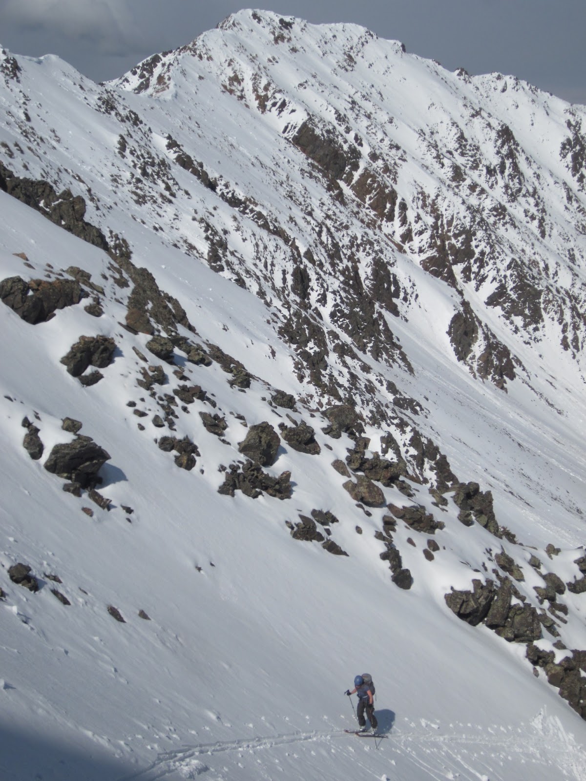
Leah skiing back into the Brannan lake cirque.
Dropping yet again into the Brannan lake cirque.

Ski tracks in the Brannan lake cirque.
Steep kick turns with the west face of Hollowtop visible in the background.
Memorial day dawned cold and wet.  We stayed in the tent until noon before heading out in the mist.  We returned to the central cirque, and re-climbed the couloir from the first day.  Leah skied the north twin couloir, and I skied a narrower couloir on the south margin of the face.  By dividing and conquering, we ticked off all the main obvious lines in the cirque.  Fortunately, the mist broke, and we skinned to the south ridge of Lakeshore Mountain, and skied an excellent, moderate gully into the Jackson peak cirque.  The weather held, and we were able to ski the north couloir of Jackson peak with good snow and crisp early evening light.  A quick jaunt up the northwest snowfields of Jackson peak rounded out another great day.
About to ski into the challenging gash couloir.
Leah skiing the excellent gully off Lakeshore mountain to the base of Jackson peak.
Climbing to Jackson peak's north couloir.
Snacking on a knoll below Jackson peak's north couloir in preparation for an evening run on the northwest shoulder.
 It rained and sleeted all night, and it was with some reluctance that we headed back up to the Branham lake cirque on Tuesday to try to ski something before heading home.  We ended up skiing another line off the northeast shoulder of the southwest peak, in the mist,  as well as a fun little mini-couloir back to Sailor lake before packing up and heading out.  It rained hard for most of the ski out, and we returned to the car soaked but happy.
Misty turns in the Brannan lake cirque before heading home.
Skiing the return gully to Sailor lake on the way home.
By the numbers,  we skied 11 new (for us) runs, 10 of them with good snow, explored four new cirques, read about 200 pages, cleaned out one bottle of Seagram's whiskey, slept for about 32 hours, and weathered about an inch of precip in the form of rain, hail, graupel, sleet, and snow. It was awesome.  A big thanks to Leah for joining me on this thoroughly enjoyable ski outing.

I also want to pass along a recommendation to Missoula skiers to give Matt Radlowski a call for ski tuning.  He spent some time overhauling my powder skis last week, and really brought them to life.  With some edge sharpening and detuning/flattening in the tips, the hookiness is gone, and I am finally happy with how Dynafit Huascarans ski.  Since I have a shameless preference for small skis (and tight clothing), at 112 mm underfoot, the Dynafit Huascarans are too wide to be a good technical mountaineering tool, and at and 1910 grams for skis and bindings, they are too heavy for super long or fast days.  However, they are now the fun/nimble/predictable powder ski I was hoping for, and coupled with Dynafit Speed superlight bindings (also recommended), and TLT5 performance boots, they are light enough for real backcountry skiing.  Viva la Dynafit!

Thursday, May 16, 2013

Post work spring skiing, 2013

The early May heat wave put Snowbowl out of commission, so it is time to start heading deeper in the hills in search of snow.  Same as last year, I plan on using this post as more of a journal, updating it throughout the spring.

Tuesday, May 7
I was unable to wrangle anyone for a post work Snowbowl ski, must have something to do with the warm spring weather.  Instead, I struck out alone to ski the southeast face of Stark mountain.  Stark mountain is kind of a sister to Chapaquan, and sits directly across the Ninemile valley.  The open bowl is clearly visible from I-90, and most of the scenic vistas in Missoula - just look for the lookout on top.  I drove all the way up to the gate at 6,000 feet on the west side, and from there it was a simple 45 minute approach to the peak.  Good road access to skiing near Missoula, who would have guessed?  The ski run was short, mellow, and enjoyable. I was surprised to see a set of bear tracks on the road, and a pair of fresh ski tracks on the peak.  In the throes of a rogue spring cold, I took my time and enjoyed the fine, warm spring day on the climb out and schuss back to the car.  Nice to finally ski this one after staring at it on the drive to work for the past few years.  About 2,000 vertical feet, and done in a little under 2 hours car to car.

Watch for Bears on the road.
This is the lookout you can see from town.
Ready to ski Stark mountain.
Tuesday, May 14
I finally made it out to Ward peak (the one by DeBorgia, not the one by Hamilton).  Parking at 4,000 feet, I jogged about 3 miles of trail through beautiful cedar forests before putting on skis and hammering up to Ward.  Mapless, I popped out on the crest of the range about a mile west of Ward, but was able to easily traverse to the summit.  I skied a fun ramp and couloir on the north face to a tarn, then booted back up to the summit and skied the East face down through the beautiful series of lakes down to Hazel lake.  The skiing was on consolidated spring corn, and was extremely enjoyable.  The evening weather was cool, clear, and calm, and I had a big grin on my face for the entire jog back out to the car.  Along with Illinois, Eagle Cliff and Stevens peak, this is one of the few peaks along the divide that has any semblance of an alpine ambience, so it was nice to see the area.  About 4,000 vertical feet, and done in 2 hour, 55 minutes car to car.
Nice terrain on Ward.
Ready to ski good corn on Ward.
That was fun.  Ward's north face with ski tracks.
Tuesday, May 21
I made an early morning push for Lolo.  I slept at the trailhead, and was jogging just before first light.  I did a simple out and back for time, and had a beautiful morning, slinking into the office at a respectable 9 am.  The snow was frozen when I skied it, but the three parties headed in after me probably found great corn.  In terms of speed, it could go faster, since I have trouble giving a full effort before 6 am. I also had several technical blunders, and was on Broad peaks, not race skis.  In any case, the car to car time was 2 hr 46 min.  Coverage is good, with only 20 minutes of jogging on the trail before donning skis.  For future reference, splits:  (trail junction 12.30; Dropping to Carton lake 1.05; arrive at summit 1.42; back at Carlton ridge 2:14).  
Orange sunrise near the top of Carlton ridge.
Looking up the northeast face of Lolo during the skate around Carton lake.
On top.

Tuesday, May 14, 2013

McDonald Peak, South face

Party on the summit of McDonald peak, Mission mountains.  Photo: Joshua Phillips
Shortly after 4 am, Leah, Joshua and I rendezvoused to ski the mighty McDonald peak.  I've been up there a few times this year, but couldn't resist the urge for another trip into the heart of the Missions.  Using my pickup, we drove to the base of the steep section on the Ashley lakes road, and were hiking at first light.  By cutting the normal switchbacks, the hike to the trailhead was quick, and we proceeded to Ashley lakes, conveniently transitioning from running shoes to skis at the outlet.   The climb into upper Ashley creek was not too bad, and from then on the day was nothing but pure joy.  We took our time enjoying the jaunt through upper Ashley creek to the base of McDonald before skinning and booting the South face.  Joshua took off and put in the booter, while Leah and I followed, grateful for his hard work.  Intermittent clouds blew out while we were on the summit, and we were treated to the incredible view from the top of the Missions.  The South face was still icy, but turned to corn near the bottom, and the entire schuss down Ashley creek was on good corn.  We took our time on the exit, treating ourselves to long breaks filled with iphone dance parties, ballerina stunts, and laughter.  We scored a ride down the last part of the road, and were soon back at the car, happy and successful.  After multiple failures, this was Joshua's first McDonald summit, and it was Leah's first attempt and first summit.  This is my 8th McDonald summit, and I hope to have many, many more summits of this beautiful, commanding mountain.  A little over 7,000 vertical feet and done in about 11 hours car to car.  
Starting around lower Ashley lake with Sheepshead looming above.
Leah styling upper Ashley creek.
Touring in upper Ashley creek.
Leah nearing the summit of McDonald peak.
Joshua skiing under the watchful eye of the southern Missions.
Leah skiing off the summit, with the green Flathead valley in the background.
Leah working the ice on the south face of McDonald.
Skiing out of upper Ashley creek.
Cutting switchbacks on the hike out.

Tuesday, May 7, 2013

McDonald Peak, North face direct

The mighty north face of McDonald in April. Route is in red.
The dotted line is the suggested route which should yield a clean descent.
John Lehrman joined me for a stellar day in the Missions on May 2, 2013.  With John's 4wd truck, we drove up the Ashley lakes road to the last switchback, and were hiking at 5:15.  The approach to the peak was straightforward, with the normal, minor tree hopping and bushwacking below snowline.  We approached and climbed Sheepshead via the northwest ridge, deviating out onto the Southwest face when the ridge became corniced.  With crampons, the ascent was quick and safe, and we summited exactly 4 hours after leaving the car.  We skied the East ridge of Sheepshead to its terminus, then dropped onto the narrow East face.  To our surprise, the snow was perfect boot top powder, and we were both elated to ski a new run in such perfect conditions.  We stopped in the sun, just above the tarn below McDonald's Northwest face and took a short break, casually eating and transitioning to skins.
Approaching Sheepshead.   All photos:  John Lehrman
Early morning climbing on the Southwest face of Sheepshead.
Nearing the summit of Sheepshead.
A straightworward skin put us on top of the mighty McDonald peak.  I had come to attempt the North face, so we traversed to the drop in point in the center of the face.  Having partially scouted the face a few weeks ago, I navigated carefully to the break in the cornice at the beginning of the line and gazed down into the abyss.  The run looked exactly as I had hoped - plastered with snow and very steep.  John decided not to drop in, so I began gingerly sideslipping 55 degree snow down to and through the first choke.  Fully engaged, I linked a series of steep but soft turns before sideslipping and sidestepping through the upper choke.  The skiing was extremely steep and technical, but conditions were excellent, and I made a bunch of turns down to the lower cliff band. Having only partially scouted the face, I checked left and didn't see a good exit, so traversed about 200' right along the face to the end of the snow.  Unfortunately, the snow strip through the cliff bands was partially covered in waterfall ice.  After contemplating a cliff huck, I decided to downclimb the final 20' cliff.  The next half hour was spent transitioning out of skis and carefully stemming and downclimbing the final chimney.  Reaching all the way to the bottom of my bag of tricks, I tossed my pack and skis down into the chimney and hopped the hopelessly ice-slicked final 10 feet of downclimbing sans skis.  On the glacier, I climbed back up to my skis and pack and enjoyed moderate turns over the bergschrund and down to a large bench.
John coming up McDonald peak with our ski tracks inthe background.
Climbing to McDonald peak.
Carefully sideslipping the upper pitch of the North face of McDonald peak.
 John was waiting patiently below the East face, so I climbed to the northeast shoulder and skied down to him.  After another relaxing break, we returned to the Post/Ashley creek divide and skied the great shoosh booming run down Ashley creek to the lakes.  I was surprised to find adequate snow coverage all the way to the outlet of the lower lake.  Back in running shoes, we hopped on the exit trail and were soon back at the truck.  The exit trail has been cleared in the past year, and is currently in great shape.  To our surprise, we saw fellow skiers Greg and Patrick at the lake, and compared notes from the day at the trailhead.  It is always exciting to see other skiers in this wild corner of Montana.  The road was slow, and the drive down took longer than walking would have, but we weren't in a hurry, and enjoyed just bumping along all the way out to the highway.
Back at the Post/Ashley divide, ready to head home.
We had a perfect day.  Powder and corn snow, blue skies, cold temperatures, wild, rugged mountains, and one of my favorite ski partners of all time will stand out in my memory long after the novelty of tackling a likely first descent of the direct North face wears off.  If anyone is interested in the North face, I would recommend using the skier's left exit, and wait for good north facing conditions late in the year with maximum coverage.  Expect very steep and complex skiing, and don't be surprised if you wonder why you aren't just cruising one of the classic corn runs instead.  By the numbers, the day ended up in the vicinity of 8,000 vertical feet, and done in about 11.5 hours car to car at a steady but casual pace.

Wednesday, May 1, 2013

Cathedral ski traverse in the Tetons

Skiing off the summit of the Grand Teton.  Photo: Mark Hammond
On April 27, 2013 I skied Teewinot, Mount Owen, and the Grand Teton in a push from the Taggart lake trailhead.  It was a great day in the mountains.  With an adequate weather forecast and excellent beta from Nate Brown and the Dorais brothers, I made the long drive and caught a few hours of sleep before rolling out of bed at 12:30 am.  A full moon cast the range in an eerie glow as I approached Bradley lakes and started up the normal skin track to Garnet and beyond.  I was fortunate to stumble on exit tracks from Glacier gulch, and followed them to Delta lake, where I re-filled water.  From the lake, I pushed up to the terminal moraine of the Teton glacier, and was pleased to easily find the large access ramp that grants easy access to the Southwest face of Teewinot.  I slowly skinned and booted the face to the point of highest snow, roughly 12,175 feet.  I did not summit Teewinot.  It was still dark, but with a brilliant moon, I skied the face sans headlamp, sideslipping carefully through endless hard ice and debris.  I had hoped that this face would be moderate enough to casually ski with icy conditions, but it ended up being slow and a little scary.

Moonset over the Red Sentinel.  I do not have any pictures
from Teewinot because I skied it in the dark.
From the base of Teewinot, I continued up to the base of the Koven couloir, stashing water and the extra tool.  I donned spikes at first light.  The couloir looked horrendous, but I headed up anyway, irrationally hoping for some warming before I had to ski the thing.  Travel conditions were punchy and slow, and it took a while to pop out at the col and into the first rays of morning light.  I drafted in an old boot and skin track to the base of the East ridge.  The old tracks traversed south around the ridge, presumably to the upper Koven route to the summit but I had no intentions of summiting.  Instead, I skinned another hundred feet or so to northeast, topping out on a wind feature at 12,550 feet and took a minute to enjoy life on the craggy, exposed slopes of Mount Owen.  About 20 powder turns brought me to the upper chimney, which I easily sideslipped.  A few more turns brought me to the top of the Koven couloir, which was still bullet proof ice.  Not wanting to sit and wait for the snow to soften, I transitioned back to spikes and downclimbed the upper Koven couloir before making a long, hard skier's right traverse above the lower Koven couloir and around the head of the Teton glacier.
The Koven Couloir at first light, not looking very user friendly.
At my high point on Mount Owen, ready to ski.
Powder high on Mount Owen, also showing my high point.
Sideslipping a chimney high on Mount Owen.
Downclimbing the upper Koven couloir.
At the base of the Teton glacier lateral moraine, I took a quick break to refuel and apply sunscreen.  It was 9:15, and the day was warming rapidly.  With a bunch of elevation already under my belt, I was moving slowly, but started the slow grind up the Dike couloir.  From the top of the couloir, I traversed the Tepee glacier, and took the normal route for the Grand to Glencoe col.  Donning spikes yet again, I started up a cold and blustery Stettner couloir.  Looking up the Chevy, I was pleased to see the ice bulges looking quite manageable, even with only one real ice tool.  As I ascended the Chevy, I started running into the cluster that must be the Grand Teton on a sunny day in May.  In a 10 minute span, I climbed up through a rap party of four, another rad rap party of two from Colorado, passed a party of two, and closed the gap on Mark Hammond and Jason True from the Wasatch.  I was tired and moving quite slowly, but still made the summit in under an hour from entering the Chevy.  I chatted with Mark and Jason on the summit for a few minutes before making a fatigued descent of the Ford.  What a run - the Grand is so amazing, and skiing on the moon never gets old.  I carefully downclimbed the Chevy and Stettner couloirs without incident, and ducked out at the base.  A small but scary wet slide came screaming through the Stettner as I was transitionig to skis, indicating that it might be past time to start heading home.  I had hoped to continue to Middle and beyond, and stubbornly made the traverse along the Black dike to the Lower Saddle.  An accomplished ski mountaineer, who I admire, once described his approach to ski mountaineering as simply putting one foot in front of the other until it became time to pull the plug.  It sounds simple, but this approach has worked well for me, inspiring me to push through doubt, physical low points, and psychological low points until the breaking point is reached, usually due to avalanche danger, poor weather or apathy.  Fatigued, intimidated, and worried about wet slides, it was the breaking point for me on that day, and I pulled the plug at the base of the North ridge of the Middle Teton.

At the end of the traverse to Lower saddle.
At the Lower saddle, where I bailed.

After a few powder turns on the lower Glacier route, the rest of the skiing to the Meadows was an exercise in over-baked corn management.  With hours of daylight remaining, I relaxed on the ski out, stopping to chat with the rad party of Coloradans camped at the Platforms (thanks for the water), and generally enjoying the beautiful, warm afternoon.  I skipped over intermittent snow into the parking lot around 4:30, absolutely exhausted.  But happy, having been treated to a triple serving of technical and engaging Teton skiing.  The rest of the weekend was spent sleeping, with a little driving home and eating thrown in for good measure.

Statistics
Total elevation gain (based on Google Earth):  11,800 feet
Trip length: 15.5 hours
Accomplices: None
Put in:  Taggart lake parking
Take out: Same
Ski equipment:  Dynafit Broad peak skis, TLT speed race bindings, Scarpa Alien boots, One whippet and one race pole.  OR Ferossi pants, Camp Nanotech crampons,  One Petzl Aztarex axe, and one CAMP Corsa axe.  Helmet. 
Ski equipment left in the car which caused extreme regret and misery:  Ski crampons
Sustinance:  Leftover Teton Thai for breakfast.  1 growler full of water with Perpetum, refilled once .  One turkey wrap.  Two chocolate bars, two Probars, and about  1,000 calories of Gu.
Trailbreaking effort:  Moderate
Avalanche conditions:  Low end of Moderate with a few lingering slabs and wet slide danger in the afternoon.
Fatigue factor (1-10): 9.8
Stoke factor (1-10): 9
Memories to suppress:  I got beat down by elevation, which is always frustrating.  Not completing the traverse.